The chance for rain returns to the area Friday.
COLUMBIA, S.C. — It was another cool start to the day. Many areas dropped into the middle to upper 40s and lower 50s. The cooler-than-normal weather will continue for a few more days.
Tuesday morning was unseasonably chilly across the Midlands. Columbia dropped to 53° for the third consecutive day.
It was even cooler in some locations. Cedar Creek had a low of 43 degrees. Camden, Manning, Newberry, Sumter and Winnsboro also dropped into the middle to upper 40s.
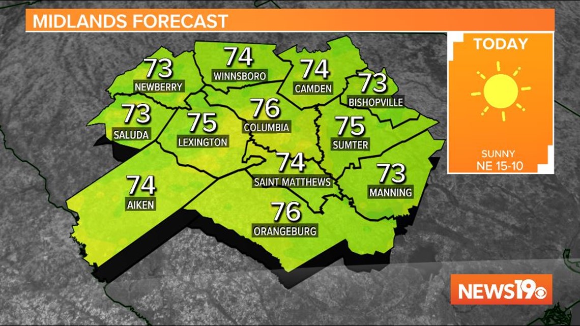
The dry, pleasant weather will continue for the next couple of days. High temperatures this afternoon will top out in the middle 70s under sunny skies. Our average high this time of year is 84 degrees.
Autumn Equinox Today:
The fall equinox was at 9:31 this morning. Even though our weather has been cooler and it is now autumn, the leaves do not change due to current weather conditions. This is a common misconception. Leaves change color because of the amount of daylight and photosynthesis.
In South Carolina, the fall colors peak on average around late October and early November. In the mountains of the North Carolina, peak is a little earlier, but we still do have some time.
Local Forecast:
For the first day of fall, high pressure will remain in control of our weather today. Mild, dry weather is in the forecast this afternoon. Highs temperatures will top out in the middle 70s.
Another cool morning is expected Wednesday. Lows will drop again into the upper 40s and lower 50s. Wednesday afternoon will be a little warmer with high temperatures in the upper 70s.
Moisture will begin to return to the area towards the end of the workweek. The high pressure system that is controlling our weather will move east and the remnants of Beta will move farther east too.
A few showers could move through the area Friday. However, there is some uncertainty as to how much rain will be around. Temperatures will climb into the upper 70s to lower 80s Friday.
More showers will be possible over the weekend. Highs will be in the lower to middle 80s.
Tracking the Tropics:
There are three storms being watched and one other area that has a small chance for development.
Beta will continue to bring heavy rain over parts of the Gulf Coast. Flash flooding and river flooding will continue as this storm slowly moves through that area.
Teddy has weakened a little, but it is still forecast to bring heavy rain, strong winds and destructive waves to Nova Scotia. It is forecast to transition to a powerful post-tropical storm as it moves generally to the north.
Post-Tropical Storm Paulette came back from the dead to become a tropical storm again. Paulette is moving east-northeast in the far northeastern Atlantic. There are no watches or warnings associated with Paulette.
The last area worth watching is producing showers and thunderstorms extending from the southeastern Bahamas westward through Cuba and into the southeastern Gulf of Mexico.
This system is forecast to move slowly southward during the next couple of days, and then move back northward on Thursday through Saturday. Development, if any, over the southeastern Gulf of Mexico late this week is expected to be slow to occur.
Regardless of development, locally heavy rainfall is possible over portions of Cuba on Tuesday and Wednesday and over the Florida Keys and south Florida on Thursday and Friday.
September 22, 2020 at 10:27PM
https://www.wltx.com/article/weather/daniels-tuesday-forecast/101-1e00e47c-5503-4a5d-85a8-a9e94356cdf3
Another sunny, dry day for the Midlands - WLTX.com
https://news.google.com/search?q=dry&hl=en-US&gl=US&ceid=US:en

No comments:
Post a Comment