
“The sunrise was taken from 57th street beach (in Avalon) — shore sunrises are the absolute best. It’s the dawn of another day in paradise.” — Monica O’Donoghue Philadelphia
Progressive, for many, means something political. In the weather world, it means fast-moving.
That is what our pattern will be like for the next seven days. Fast-moving storm systems will bring us dribs and drabs of rain, with dry periods that won’t last that long, either.
Temperatures on Sunday morning will be seasonable for late October, with mid-40s in Mullica Township and the mainland and low 50s in Margate and the shore. However, compared to this past week, it will feel chilly out. We’ll have a little bit of sunshine to start.
Sun will fade to clouds quickly, though, as a warm front lifts up the East Coast, nearing us. Combine that with a northeasterly wind, and temperatures won’t be all that high. Generally, we’ll be in the 55- to 60-degree range. Still comfortable for a workout, but you’ll want the extra layer just walking around or tackling some outdoor work.
In terms of rain, showers look to arrive between 3 and 5 p.m. I can’t rule out those of you in Lower Cape May seeing a shower after noon, but it won’t be a soaking rain if it did.
Rain showers will continue through the evening. Winds will kick up out of the northeast a little bit. Thankfully, with the quarter-moon Friday, tides will stay below flood stage.
Look for showers to end early Monday, between 3 and 5 a.m. Fog, a friendly foe of ours this past week, will be present into the morning. Low temperatures will be around 50 inland, with mid-50s at the shore. Leave the windows open at night.
The fog will turn to sunshine Monday. When we get the sun, we’ll turn warm. We’ll go well into the 60s for highs, about 5 degrees above average for this time of the year.
Monday night should be dry but on the cloudy side. Like a blanket, it will keep the heat on the day toward the ground and not have it escape to outer space. It’ll be comfortable for outdoor dining during the evening, with temperatures sliding through the 60s. Overnight, we’ll be in the 50s.
A cold front will slice through Tuesday, but most of the day should be dry. Overnight, it appears high pressure will eat up most of this rain. As a result, expect a dry morning. Showers will start between 2 and 4 p.m. Outdoor projects can still get done if you have some tolerance to rain, though. Showers will continue into the evening, with highs 60 to 65 degrees.
High pressure will slide in from the west, kicking out the rain by sunrise Wednesday. High pressure will be fast to get out of our way but hang on long enough for a dry, crisp fall day. Highs will be in the mid-60s.
The forecast will be murky for Thursday into Friday. There will be rain, likely heavy at times. Strong onshore winds and coastal flooding will be possible, too. As of now, Thursday still looks to be the wetter day.
As mentioned in the previous column, expect a cool to chilly Halloween.
The 2020 Hurricane Season should be the second most active on record
The most recent, Aug. 5, Atlantic Hurricane season update from Colorado State University (CSU) forecasts in total tropical activity take a large step up, enough to make the 2020 hurricane season the second most active on record.
As of Aug. 5, nine named storms have formed in the Atlantic Hurricane basin, which includes the Gulf of Mexico. That is on pace to break the record, last set in 2005. Given this, CSU forecasts 24, named tropical storms or hurricanes to occur. That is an increase from the 20 last predicted in the July update. Out of the 24, 12 hurricanes and 5 major, category 3 or greater (at least 111 mph sustained winds) are forecasted.
In July, the number of forecasted hurricanes and major hurricanes were 19 and 9, respectively.
"We have increased our forecast and now call for an extremely active 2020 Atlantic hurricane season" the CSU report read, which is led by Philip J. Klotzbach, Michael M. Bell, and Jhordanna Jones.
Comparison of recently-released @ColoradoStateU and @NOAA seasonal #hurricane forecasts for the 2020 Atlantic hurricane season. Both call for very active season - CSU forecast generally slightly to somewhat higher than midpoint of NOAA range. pic.twitter.com/AiM0caox5k
— Philip Klotzbach (@philklotzbach) August 6, 2020
The 1981-2010 average of activity includes 12.1 tropical storms, 6.4 hurricanes and 2.7 major hurricanes, respectively.
There still remains an above average risk of a major hurricane making landfall on the East Coast of the United States, including the Florida Peninsula. The 49% chance is an increase from 45% in the July update. On average, there has been a 31% probability of a strike in the last century.
CSU attributes warmer than average waters in the subtropical Atlantic Ocean, slightly warmer than average waters in the tropical Atlantic as reasons for the active forecast. Furthermore, there's a lack of wind shear, or change of winds with height, which can rip storms apart. A transition from the current El Nino Southern Oscillation (ENSO) neutral state to a La Nina late in the summer puts more confidence that wind shear will remain light.
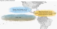
What happens in a La Niña, which may develop late in the summer into the fall.
Tropical cyclone names rotate every six years. Exceptionally notable hurricane names, such as Sandy, become retired by the World Meteorological Organization. However, no names were retired in 2014, meaning 2020 will have the same list as then.
Arthur - Used
It's the sixth year in a row that a named tropical system has developed in the Atlantic Hurricane Basin before the June 1 official start.
Bertha - Used
Tropical Storm Bertha is the second tropical storm or greater storm to have formed in the Atlantic Hurricane basin before the official start June 1. This is only the sixth time since records have been kept in the 1700s that two tropical storm or greater storms have formed before the start.
Cristobal - Used
Dolly - Used
Dolly was the third earliest fourth named (D storm) storm in Atlantic Hurricane history, which goes back to 1851. It also flared up further north than any tropical storm before July 1 in recorded history, according to Sam Lilo, postdoctoral researcher at the National Oceanic and Atmospheric Administration
#Dolly has formed in the North Atlantic - the 3rd earliest 4th Atlantic named storm formation on record (since 1851). Danielle is earliest on 6/20/2016. Debby is 2nd earliest on 6/23/2012 at 12 UTC. Dolly in 2020 formed on June 23 at 1615 UTC. #hurricane pic.twitter.com/1Ha6ZnxHqc
— Philip Klotzbach (@philklotzbach) June 23, 2020
Edouard - Used
The Atlantic Hurricane season continued its blistering pace. Edouard, which developed July 6, was the earliest fifth named (with the letter "E") storm in Atlantic Hurricane history, which goes back to 1851. This is according to Philip Klotzbach, Meteorologist at Colorado State University, who issues a highly reputable hurricane forecast each year and is used by The Press.
#Edouard has formed in the far North Atlantic - the earliest 5th Atlantic named storm on record. Previous record was Emily in 2005 on July 12 at 0 UTC. #hurricane pic.twitter.com/K7cB6UKUnq
— Philip Klotzbach (@philklotzbach) July 6, 2020
The previous record was held in 2005 with Emily, which occurred on July 12. 2005 holds the record for the most active hurricane season on record in the Atlantic Hurricane basin, with 27 named storms.
However, all of the storms to this point have all been tropical storms. Some, like Edouard, likely would not have even been noticed before the satellite era, as they were out to sea and may have been missed by shipping routes.
Fay - Used
Tropical Storm Fay will go in the record books for multiple reasons.
- It is the tenth tropical storm or hurricane to make landfall in New Jersey since 1900.
- It made landfall just south of Holgate, on Long Beach Island, this is, incredibly, about ten miles away from where Tropical Storm Irene and Superstorm Sandy made landfall, right near Brigantine.
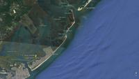
Tropical Storm Irene, Superstorm Sandy and Tropical Storm Fay, in a twist of Meteorological conciendence, all made landfall just miles apart.
- Fay was the earliest sixth tropical storm or hurricane to form in the Atlantic Hurricane basin, since records started in 1851. On other words, it was the earliest "F" storm on record.
Gonzalo - Used
Tropical Storm Gonzalo formed as a tropical depression July 21 and turned into a named storm July 22.
Hanna - Used
Tropical Storm Hanna formed Thursday, July 24. That put the 2020 hurricane season in a big lead over the 2005 hurricane season for the quickest, most active start. In 2005, Harvey formed on August 3, putting the 2020 season roughly two weeks ahead of 2005.
According to Retired National Weather Service Meteorologist Jim Eberwine, this was the first time in 22 that there have been eight tropical storms, without any hurricanes. However, its upgrade to a hurricane July 25 meant this streak was broken.
#Hanna has formed in the Gulf of Mexico - the earliest 8th Atlantic named storm formation on record. Prior record was Harvey on August 3, 2005. #hurricane pic.twitter.com/m1cuFjb0ff
— Philip Klotzbach (@philklotzbach) July 24, 2020
Isaias - Used
The fourth largest power outage event in Atlantic City Electric's history came with Isaias, which passed to the west of New Jersey as a tropical storm.
Isaias continues the blistering pace of the hurricane season, beating out the 2005 season. The "I" storm then, Irene, developed on August 7.
This also ties the record for the most number of July tropical systems in a month, at five.
Josephine - Used
Tropical Storm Josephine formed Aug. 13, after spending time as a Tropical Depression for a couple of days. According to Klotzbach, this is the earliest tenth named storm of the Atlantic Hurricane season on record, best 2005 by nine days.
#Josephine has formed in the central tropical Atlantic - the earliest Atlantic 10th Atlantic named storm on record. Prior record was Jose on August 22, 2005. #hurricane pic.twitter.com/v9tdJ0wpmS
— Philip Klotzbach (@philklotzbach) August 13, 2020
Kyle - Used
Tropical Storm Kyle developed Aug. 14 well off the Delmarva coast.
This outpaces 2005 by ten days. On Aug. 24, 2005, Hurricane Katrina formed.
Low pressure area south of Nantucket now has 70% chance of tropical cyclone development in next 2 days. If it gets named, it would be Kyle. Current record for earliest ‘K’ storm is Katrina on August 24, 2005. #hurricane pic.twitter.com/pLn5OycAjK
— Philip Klotzbach (@philklotzbach) August 14, 2020
Laura - Used
Tropical Depression 13 turned into Tropical Storm Laura.
According to Klotzbach, Laura is the earlier "L" storm on record, beating out Luis in 1995.
Laura is forecasted to make landfall on the Gulf Coast Wednesday, doing so at nearly the same time as what will be Marco.
Marco - Used
The previous record for the earliest thirteenth storm of the year was Sept. 2.
#Marco has formed in the NW Caribbean - the earliest 13th Atlantic named storm formation on record. Prior record was a tie on September 2 at 12 UTC between Maria (2005) and Lee (2011). #hurricane pic.twitter.com/bDHFT123dZ
— Philip Klotzbach (@philklotzbach) August 22, 2020
Nana - Used
Omar - Used
Tropical Storm Omar formed off the North Carolina coast on Sept. 1. 2020 continues to lap other hurricane seasons for the most active on record. According to Klotzbach, the second earlier "O" (fifthteen) named storm was Ophelia on Sept. 7, 2005.
Tropical Storm #Omar has formed off of the North Carolina coast - the 15th named storm of the 2020 Atlantic #hurricane season to date. The previous record for earliest 15th Atlantic named storm formation was Ophelia on September 7, 2005 at 6UTC. pic.twitter.com/YHEizBrdzN
— Philip Klotzbach (@philklotzbach) September 1, 2020
Paulette - Used (again)
After a five day hiatus, Paulette turned back into a tropical system on Sept. 21, morphing into a tropical storm. According to Klotzbach, Paulette was the first hurricane to become post-tropical and then redevelop since Ivan, in 2004. Ivan was brought back into the spotlight this year for having a very similar look and landfall as Hurricane Sally. Sally crashed into Alabama earlier in September.
Paulette's eye went right over Bermuda as a hurricane, though little damage was seen on the resilient island.
Rene - Used
Tropical Storm Rene formed off the coast of Africa on September 7. According to Klotzbach, this outpaces the 2005 Atlantic Hurricane Season for the most active on record. Rita formed on September 18.
#Rene has formed in the eastern tropical Atlantic - the 17th named storm of the 2020 Atlantic #hurricane season to date. Rene is the earliest forming 17th Atlantic named storm on record, breaking old record set by Rita on September 18, 2005. pic.twitter.com/5gKXDXdoOE
— Philip Klotzbach (@philklotzbach) September 7, 2020
Sally - Used
Teddy - Used
Teddy formed on Sept. 14, 2020. The blistering pace of the Atlantic Hurricane season continues, beating out the 2005's nineteenth named storm by nearly two and a half weeks.
#Teddy has formed in the central tropical Atlantic - the earliest 19th Atlantic named storm formation on record. Prior record was October 4, 2005 (Unnamed). Unnamed storm was added in post-season reanalysis in 2005. #hurricane pic.twitter.com/SAnhkoHKs5
— Philip Klotzbach (@philklotzbach) September 14, 2020
Vicky - Used
#Vicky has formed in far eastern tropical Atlantic - the 20th named storm of the 2020 Atlantic #hurricane season to date. Vicky is earliest 20th Atlantic named storm on record, breaking old record set by Tammy on October 5, 2005. pic.twitter.com/EmxNj6352O
— Philip Klotzbach (@philklotzbach) September 14, 2020
Wilfred - Used
#Wilfred has formed in the eastern tropical Atlantic - the 21st named storm of the 2020 Atlantic #hurricane season to date and earliest 21st Atlantic named storm on record. Prior record for earliest 21st named storm was October 8, 2005. pic.twitter.com/t8kGhASX13
— Philip Klotzbach (@philklotzbach) September 18, 2020
Wilfred exhausts the list of hurricane names for the Tropical Atlantic Ocean. It is in the earliest twenty-first storm on record, beating out 2005's storm, which formed on Oct. 8.
For the second time in history, Greek names will be used to name storms
We go Greek.
The rules for hurricane names state that once the list is exhausted, storm names go by Greek letter of the alphabet. This has only been used once, and that was for the 2005 Atlantic Hurricane season that 2020 is on pace to break.
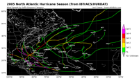
The 2005 Atlantic Hurricane season in the most active on record, which goes back to 1851 (though the advent of weather satellites in the 1960s means hurricane seasons before then may not have been accurately calculated). That year 28 named storms developed, exhausting the alphabet list of storms. The NHC then had to turn to the Greek Alphabet for names.
The next five storm names after Wilfred go in the following order:

For storms that cause massive destruction, any member state of the World Meteorological Organization can ask to retire the name. The WMO Hurricane Committee then votes on it. Member states can apply to have a greek alphabet name retired in 2020. If the WMO approved it, the name will go into the "retired" list, but still be used whenever needed.
Retiring storm names are uncommon. Between 2010-2019, only 15 out of the at least 210 potential names will not be used again, 7.1%.
Joe's 7-Day Forecast
Alpha - Used
For the second time in history and the first time since 2005 the list of storm names have been exhausted.
Subtropical storm Alpha is the first Greek storm name of the season. Perhaps fitting for its name, it has charted its own path, crashing into Portugal as a mid-level stom Sept. 18.
Beta - Used
Gamma - Used
After a break for nearly a week, Gamma spawned in the Gulf of Mexico. According to Klotzbach, Gamma is aggressively beating out the 2005 season.
Tropical Storm #Gamma has formed in the NW Caribbean - the 24th named storm of the 2020 Atlantic #hurricane season to date. Gamma is the earliest forming 24th Atlantic named storm on record, breaking the old record set on October 27, 2005. pic.twitter.com/A9Wvln4VnG
— Philip Klotzbach (@philklotzbach) October 2, 2020
Delta - Used
Tropical Storm Delta formed from a tropical depression on Oct. 5. Delta is forecasted bring impacts to the U.S. Gulf Coast late in the week.
Note that storms in the Greek alphabet can be retired if they are significant enough. However, the World Meteorological Organization will continue to use the storm name if the situation warrants. Only 2005 has even had storm names in the Greek alphabet, so it is a rare occurrence.
Epsilon - In Progress
#Epsilon has formed in central subtropical Atlantic - the earliest 26th Atlantic named storm formation on record. Prior record was November 22, 2005 (Delta). Additional storm in October 2005 added after the season, which is why Epsilon breaking record set by Delta. #hurricane pic.twitter.com/NeyB1l6yrD
— Philip Klotzbach (@philklotzbach) October 19, 2020
According to Klotzbach, Epsilon, which formed on Oct. 19, is the earliest 26th named storm of the season in recorded history. In 2005, that storm developed on Nov. 22, 2005.
Subscribe to our Daily Headlines newsletter.
October 25, 2020 at 03:00PM
https://pressofatlanticcity.com/news/local/weather-progressive-pattern-means-flip-flopping-between-wet-dry-days/article_3db16181-64f7-53da-a14c-733121a3bd87.html
Weather: 'Progressive' pattern means flip-flopping between wet, dry days - Press of Atlantic City
https://news.google.com/search?q=dry&hl=en-US&gl=US&ceid=US:en




No comments:
Post a Comment