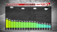
We've successfully gotten through a wintry mix and now rain is set to fall through the night into Wednesday morning. This system will slowly push south throughout the day, leaving most areas north of I-70 dry for the better part of Wednesday. Areas south of I-70 will have a chance for lingering showers into the afternoon and a few flurries or a brief snow shower. Any snow that may accumulate is not expected to amount to more than a couple tenths of an inch.
Note that winds will also gust around 25 mph throughout the day from the northwest.

Therefore, no big issues are expected on Wednesday. Wooo!!
Total rainfall accumulations up to an inch are expected for most areas.
GOODBYE 2020
The year that shall not be named going forward will end with, what else, the chance for snow... and freezing rain.
The vast majority of Thursday will be dry. We may even see the sun! (WOW, I know!)
After 7pm, from the south, our final storm of 2020 and the first of 2021 will begin to move in. This will lead to evening snow or sleet showers which are expected to quickly change to freezing rain, if not start with freezing rain altogether.

As the night progresses this freezing rain may intensify. The thing is, if it rains too heavily there isn't enough time for it to stick to anything and accumulate ice. Therefore, we may not end up with much ice. Please stay tuned as we track temperatures throughout the atmosphere for Thursday night over the coming days.
Regardless, travel concerns are certainly there for New Year's Eve festivities. Please be safe.
HELLO 2021
Any freezing rain before sunrise on Friday will change to rain as temps warm. Rain is expected to continue through much of the morning.
As we get more cold air in the afternoon, mainly north of I-70, we may see yet another precipitation switch, this time from rain to snow.
Areas north of I-70 may see snow in the afternoon and midday on Friday. It is too early to know accumulation potential, but accumulation is possible. We'll have a better idea tomorrow.

SATURDAY SNOW, TOO??
Yes, another shortwave is looking more and more likely on Saturday which may bring a quick dusting to an inch of snow on Saturday during the day. Still plenty of time for this one to change, it's just a passing energy wave and can easily shift or run into drier air and fizzle, so please stay tuned.
WARMER WEATHER
Okay, if you want it, I've got it. Temperatures will once again go 10 to 15 degrees above average starting Sunday and continuing into the first full week of January. That means highs in the 40s and 50s and lows in the 30s.

December 30, 2020 at 10:46AM
https://www.komu.com/weather/forecast-a-rainy-night-will-lead-to-dry-time-on-wednesday/article_d5f4e91e-4a46-11eb-87d8-3786e20a3f37.html
Forecast: A rainy night will lead to dry time on Wednesday - KOMU 8
https://news.google.com/search?q=dry&hl=en-US&gl=US&ceid=US:en

No comments:
Post a Comment