A surge of summery air will be coming for the end of the week.
Sunday will follow on the heels of Saturday with warm air. We’ll watch for an evening shower, but that will be all. Then, a ridge of high pressure anchors in, bringing a gradual rise to summer air this week.
We’ll kick off Sunday with a mix of sun and clouds. Temperatures are staying very seasonable for this time of year. That means 50 to 55 degrees, generally.
High pressure remains nearby, just to our east, but it will be weaker than Saturday. A pressure trough, or area of relatively lower pressure, will be in the northern half of the state during the day, with a stationary front in Virginia.
All of this is to say there will be some clouds around, but it will be dry. High temperatures will get into the mid-70s inland with the shore in the upper 60s.
There is a tweak to the forecast for Sunday night. It now looks like the potential for a shower will be before midnight, rather than after. Even with the switch, the point remains the same from the past two days. It’ll be a mostly dry night in the area, with just very spotty showers. Evening temperatures will slide through the 60s. Overnight lows will be in the 50s.

David Velasco, of Daja Hair Salon in Ventnor, answers whether you can really break off your …
Monday will see a mix of clouds and sun. That pressure trough will sit along the New Jersey Turnpike corridor. Outdoor plans look good, though, on what I believe to be a dry day. With a few more sun-blocking clouds around, we’ll be just a touch cooler than Sunday.
Monday night will keep the same theme. Yes, there will be clouds, but it will be dry. At night, clouds will trap the heat from the day in, so we’ll actually be a bit milder than Sunday night. You’ll just need a sweater or light jacket to be comfortable.
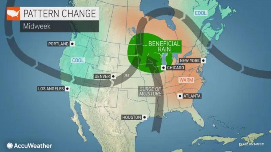
Then, a ridge of high pressure will build in the upper levels of the atmosphere over the eastern half of the United States. With the jet stream way to the north, warm air from Florida and the Caribbean will move in.
Each day will see high and low temperatures jump a few degrees on the thermometer until about Friday. That means low to mid-70s Tuesday, mid-70s to low 80s Wednesday and even mid-80s for highs on the mainland Thursday. Friday will be a bona fide beach day as we top out in the upper 70s at the shore.
The next shot of (much needed) rain may be Friday into Friday night as a back door cold front tries to sink in.
Finally, switching to tropical news, the National Hurricane Center has begun to issue tropical weather outlooks. Though hurricane season doesn’t officially begin in the Atlantic until June 1, given that each year since 2015 has had a named storm before the start date, the NHC has decided to do this.
It’s possible that by the end of the decade, hurricane season will have a new, earlier, official start date.
May 16, 2021 at 04:00PM
https://pressofatlanticcity.com/weather/weather-likely-dry-sunday-then-get-ready-for-summer-to-come/article_e41ff439-e06c-5cca-871b-916388540cab.html
Weather: Likely dry Sunday, then get ready for summer to come - Press of Atlantic City
https://news.google.com/search?q=dry&hl=en-US&gl=US&ceid=US:en


No comments:
Post a Comment