Sunday will kick off a three-day streak of dry weather. There will be a little something for everyone, too; it will range from not too hot to not too humid Sunday, and feature sultry, balmy air Tuesday.
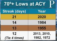
Temperatures on Sunday morning will be in the upper 60s on the mainland, with low 70s at the shore, right on target for early August. By the skin of our teeth, the streak of consecutive days with a low temperature over 70 degrees at Atlantic City International Airport actually was snapped Friday at 21. It dropped to 69 degrees, and the only reason it did was because rain-cooled air from our powerful thunderstorms Friday evening came through. The old record was way in the rearview mirror, at 14, in 1984. Incredible, incredible persistence of warmth and something we’ll see more of in the decades ahead. Sen. Frank S. Farley Marina is still holding strong at 29 days chasing the 33-day streak in 2018.

High pressure will build in the wake of an upper level area of low-pressure system which was responsible for Friday night’s storms, which, by the way, broke a rainfall record at Atlantic City International Airport with 3.17 inches of rain. Winds will be calm but eventually turn to the southwest. Even with the southwest winds, though, our dew points will be lower, in the mid- to upper 60s. Aided by plenty of sunshine, beach trips, fishing trips, outdoor projects and more will all be excellent. High temperatures will rise into the low and mid-80s.
If you’re trying to hang onto the weekend as long as possible Sunday night, you’ll be in for a treat. We’ll have a mainly clear sky, and temperatures will be comfortable, sliding into the 70s during the evening. Overnight, it will turn more sticky, so keep the air conditioner or fans on. Low temperatures will be 70 to 75, responding to the higher dew points.
Monday and Tuesday will be about the same. It will be sultry out. Each morning will start with sunshine, mixing with a few afternoon clouds. The rain chances will be close to 0%. That’s been the case for Monday for a while, but even now, Tuesday looks to hold out dry, as a strong upper level low-pressure system looks to take its time to come in. That Tuesday forecast can change, but if you have outdoor activities going on, expect them to be OK for now.
Highs in Weymouth Township and inland spots will be around 90, feeling like 100 during the middle of the day. Southwest winds will allow for a sea breeze to develop, so expect mid-80s there.
Wednesday’s forecast will feature nearly the same heat and humidity. However, at this point, that low-pressure system looks to come in. Afternoon storms looks likely, and severe weather will not be ruled out.
Here's the highest wind gusts
A wind gust is a brief increase in the wind. Wind gusts are higher than the sustained winds, which are covered below.
62 mph - Wildwood
63 mph - Beach Haven
64 mph - Tuckerton
65 mph - Beach Haven
65 mph - Little Egg Harbor
66 mph - Atlantic City International Airport
66 mph - Pleasantville
70 mph - Little Egg Harbor
72 mph - Ocean City

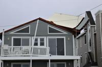
A portion of a roof was uplifted from a house on Central Avenue in Ocean City on Tuesday due to Tropical Storm Isaias.
75 mph - Cape May

Beach behind the Cape May May Convention Convention Center.
The highest wind gust in the region was taken from a senor right at the Cape May Harbor. Hurricane sustained winds, for reference, start at 74 mph.
What about that 109 mph wind gust?
The 109 mph wind gust, reported in Ship Bottom, was a weather station caught in the path of an Enhanced Fujita scale 1 rated tornado that passed through Tuesday morning.

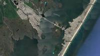
Here is the start and end points of the August 4, 2020, tornado that started as a waterspout near Ship Bottom. It turned into a tornado the moment it went onto land just outside the Mud City section of Stafford Township.
The highest wind gust in New Jersey's history was a 108 mph wind gust that whipped through Newark during the "Great Thanksgiving Storm" of 1950. There is pending confirmation on whether the 109 mph gusts was the windiest in state history.
The tornado was one of two in the state Tuesday, the other being another EF-1 twister that cut through Upper Township.
Here were places that saw tropical storm force sustained winds

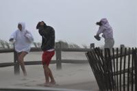
People brace themselves against the winds in Ocean City as Tropical Storm Isaias batters the East Coast.
Tropical force sustained winds, the winds that are constantly blowing, are enough to prevent emergency personnel from going out and responding to calls. Clocking in over 39 mph sustained, here were the locations that reported these strong winds.
39 mph - Strathmere
Strathmere was also the starting point for a tornado that cut from the island into the Marmora section of Upper Township. Maximum winds clocked in at 100 mph and it was the first tornado in Cape May County since 2003.
40 mph - Atlantic City International Airport
41 mph - Pleasantville
42 mph - Sea Isle City
44 mph - Tuckerton
44 mph - Cape May County Airport
Cape May County Airport is located within Lower Township.
45 mph - Ship Bottom
50 mph - Harvey Cedars
59 mph - Fortescue
August 09, 2020 at 10:45AM
https://pressofatlanticcity.com/weather/stretch-of-dry-weather-ahead-after-record-breaking-rain-friday/article_868b3e50-09eb-5097-aa29-f4d66a5afe42.html
Stretch of dry weather ahead after record breaking rain Friday - Press of Atlantic City
https://news.google.com/search?q=dry&hl=en-US&gl=US&ceid=US:en


No comments:
Post a Comment