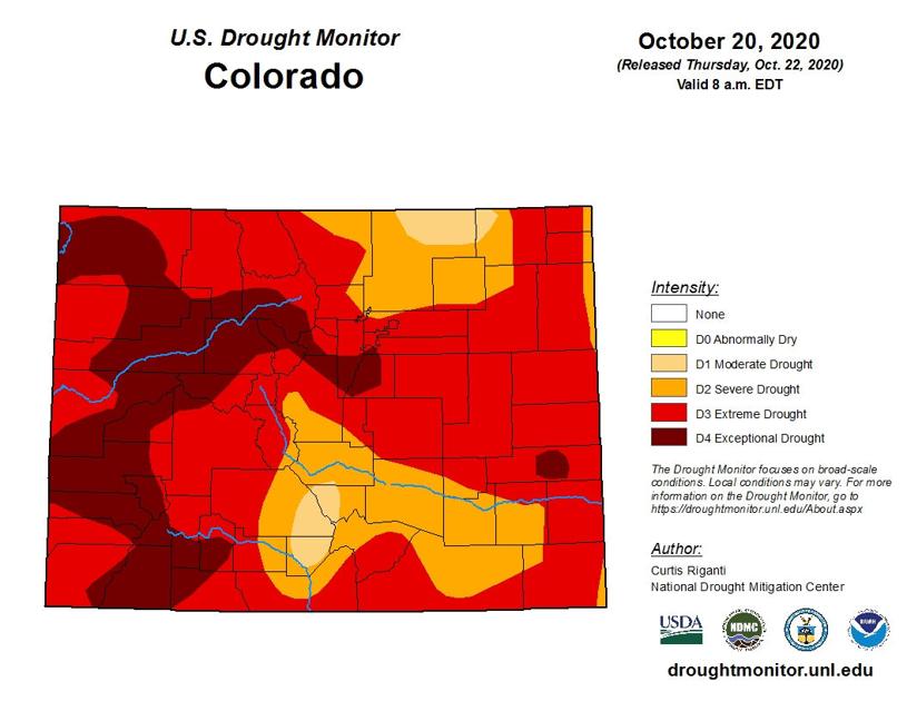
Every picture tells a story, the saying goes, and this is not a pretty one.
Or rather, these aren’t pretty: two images, a pair of U.S. Drought Monitor graphics of the state of Colorado, released on successive Thursdays this week (the latest was yesterday), depict the entire state of Colorado in a drought.
The situation is worst by far on the Western Slope, where vast swaths of landscape are dubbed D4, the highest on the scale, for “exceptional drought.”
And the exceptional dry is spreading.
In just one week, between Oct. 13 to Oct. 20, the latest map reveals, the “exceptional” drought already blanketing much of Ouray, Montrose and San Miguel counties had gained ground to encompass much of Archuleta, Hinsdale and Mineral counties, as well. The latter trio, which were considered to be in “extreme” drought up until this week, are located just east of San Juan County (which is also under an “exceptional” drought, and is where this region’s most recent conflagration, the Ice fire, had burned one square mile and was 25 percent contained as of Thursday morning).
Curtis Riganti of the National Drought Mitigation Center — a team of climate experts at the University of Nebraska in Lincoln — produced the maps of Colorado these past two weeks. He recalled camping with friends at Ridgway State Reservoir in June of 2019, “right after a blockbuster year that you had in terms of snow,” as he put it. “The trouble (that produced the current drought) kind of started during the period of summer-into-fall of that year,” Riganti said. “We’re looking at a drought that goes back toward that period.” There wasn’t much in the way of moisture during the summer 2019 monsoon, Riganti noted, “and it didn’t help that precipitation this past spring, and the summer monsoon season, were pretty muted.” The result, according to Riganti: “We’re looking at both short-term and long-term drought conditions in southwest Colorado right now. Part of the problem you’re getting with all the fires is that it’s a tinderbox. And the warm and windy conditions haven’t been helpful.”
Riganti was out here not only in 2019, but again recently, hiking with friends above Telluride and in the Cimarron Range, overlooking Owl Creek Pass. “I noticed how full the Ridgway reservoir was in 2019, compared to how low it is now,” he remarked ruefully. “Exactly how much precipitation will be needed to recover from the drought is impossible for me to say. But one precipitation event isn’t going to do it.”
At least it will be a start: the forecast this weekend is for “a pretty good system” to hit the San Juans, National Weather Service hydro-meteorological technician Dan Cuevas said. “There’s a chance of rain and snow showers after 1 a.m. in Telluride Saturday night and continuing through the day Sunday, and snow showers are also likely Sunday night. There’s also a chance of scattered snowshowers through Tuesday, as this system slowly moves out through the east.” (The forecast holds for Ridgway, where the moisture is expected to be more in the form of rain rather than snow.)
Peter Gobel, a Colorado Climate Center ‘service’ climatologist who splits his time between scientific research and public education, addressed the subject of the drought in an interview with the Planet on Thursday afternoon.
“The drought and the wildfires aren’t really separable from each other,” Gobel pointed out. “We’re in the throes of an unprecedented ecological drought: as soon as the wildfires start, they take off to beat the band. The East Troublesome fire (out of Granby) grew over 100,000 acres in a 24-hour period. Prior to this year, just three fires had grown to that size at all.”
Closer to home, “much of the San Juans have had their driest summer, and nearly their fall, on record. I suspect the fire danger is really quite high there, as well. We need snow, and a nice cold snap, where we can really press our advantage when it comes to these fires. We really need a good snow year to hit the ‘reset’ button. An average snow year would do a lot, but it wouldn’t get us all the way to recovery. We need two to three good snow years in a row.”
In some ways, Gobel added, “this year has rewritten the script when it comes to wildfire behavior. The 416 fire two years ago (out of Durango) started in June,” he pointed out. “We figured we had a good handle on why that was: we figured that because we get a lot warmer in June, and the sun is nice and high, conditions are dry, and things can become a tinderbox. We hadn’t seen a year where so many large wildfires started later; the ones this year have quickly gotten enormous. Typically, summer moisture, in terms of the monsoon,” eases dry conditions. “And by fall, you have cooler temperatures,” Goble added, “and after that, the snowpack settles in. And so the fire season, at least at higher elevations, comes to an end. We saw snow in early September, but then the weather pattern quickly reverted to hot and dry. Typically, we would have had one or two or more snow events by this point in Southwestern Colorado. This is right around the time that we start to see snow hang around on the ground. We’re hoping that this next event will start that process.”
The Link LonkOctober 23, 2020 at 06:35AM
https://www.telluridenews.com/news/article_3aa68ab0-14bf-11eb-91f8-4ff97a97074c.html
The dry-up continues | News | telluridenews.com - The Daily Planet
https://news.google.com/search?q=dry&hl=en-US&gl=US&ceid=US:en

No comments:
Post a Comment